Published Thu 7th Jul 2022
Breakthrough with Modern Monitoring Systems
Every Asset Owner or Ops Manager will tell you they have a few structures, a few sites, that keep them awake at night. Whether it is a slope stability issue that threatens their railroad tracks or roadway, or a bridge that has scour issues, these situations can be worrisome and can change at a moment’s notice, particularly during certain weather conditions.
Keeping an eye on your problem assets and structures can be time consuming and expensive. Mobilization costs to get a crew out to a site to survey the situation can add up quickly and still only offer a snapshot of the situation. Additionally, when extreme weather events can compromise the stability of a site, getting personnel there can be slow in terms of response time and in some cases dangerous.
- What if you could get information from your “problem sites” in near real-time and when you need it the most?
- What if that information came with photos of the site that you could access from anywhere?
- What if you could reduce your mobilization costs by 80%?
In the past, condition monitoring, instrumentation and monitoring, and structural health monitoring systems were expensive and involved running power and a large number of communication cables over long distances. Then it would take days or even weeks to deliver piles of data that was often difficult to interpret.
![]() This is not the case with modern systems.
This is not the case with modern systems.
In the past, some engineers and owners became frustrated with this process and gave up on expensive systems just stop looking at the data altogether. Many decided that this kind of monitoring was a waste of time and money - but with advances in battery life, data processing algorithms, and miniaturization of sensors, some systems on the market today can deliver what was promised in the past.
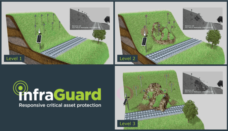
Picture a wireless system with a battery life of 10 years that offers real information when a change occurs at your site which you need to know about. A system that wakes up during a trigger event, collects more data in real-time and sends you not only an alert, but also a photo of the situation. All done in minutes and delivered to you wirelessly, hours before a crew could be deployed to the site.
The InfraGuard™ system from Senceive does this at an 80% reduction in cost to you over the conventional repeated surveys, visual inspections, and associated mobilization costs. The information provided is easy to understand and comes with a visual verification from an on-site camera so you can have eyes on the situation. Intuitively, when the trigger is more severe and you require more granular information, the system will automatically increase its sampling rate based upon the threshold exceeded, so you can assess the problem in near real-time.
For More Information: Please contact a Senceive Expert in North America today at (281) 881-9570 or usa_info@senceive.com.


