Earthworks Monitoring – Kent, Sussex & Wessex
Challenge
UK rail infrastructure operator Network Rail is responsible for around 190,000 earth structures, including a large number of steep cuttings and embankments. These were mostly built more than 130 years ago and therefore pre-date modern geotechnical standards and best practice. The safe and efficient operation of the railway depends on the stability of these structures and failure events such as landslips on cutting faces adjacent to the track can cause significant disruption and danger. The number of such failures is increasing as a result of changing weather patterns which have brought increasingly frequent periods of extreme rainfall.
A number of the routes to the south and west of London in Kent, Sussex and Wessex are especially vulnerable to such events because many cutting faces are steep, close to the track and comprise layers of permeable chalk over impermeable clay.
In order to mitigate the growing risk associated with their inventory of earth structures, Network Rail engineers and asset managers gather a range of data to influence their asset management approach.
Solution
The use of remote slope monitoring has become an integral part of this data gathering exercise. In 2018 a small-scale installation of 20 tilt sensors and two cameras at Barnehurst on the Bexleyheath Line in 2018 provided Network Rail with enough warning of a landslip to stop trains and prevent a collision with tonnes of earth and vegetation.
Further to this success, a decision was made to invest approximately £6 million on intelligent earthworks monitoring in Kent and Sussex, with the intention of commissioning the system before the winter storm season of 2020/21.
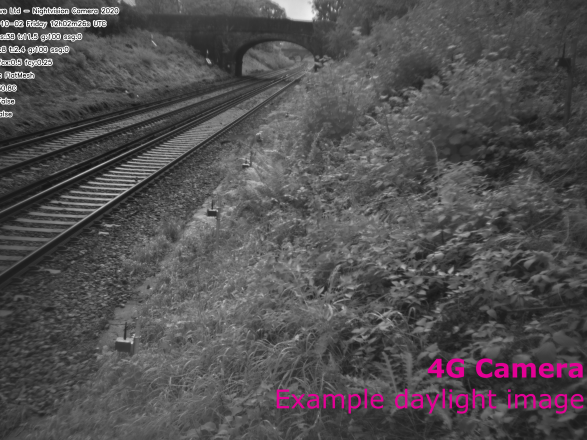
A typical InfraGuard™ deployment comprises offset rows of tilt sensing nodes fixed to metal stakes, together with a 4G communication Gateway and a 4G camera capable of operating in virtually all light conditions.
In order to make the deployment efficient and simple enough to be performed by non-specialists, a standardised approach was taken. Each site was divided into blocks of 100 m. Within each block, 50 tilt sensor nodes, two cameras and one solar-powered cellular communications Gateway were installed.
The solution is flexible and scalable. At some sites just a few tilt sensors and a pair of cameras were deployed. The longest site, at Haywards Heath, had 20 Gateways, 40 cameras and 996 tilt sensors. A total length of 9.7 km was instrumented in Sussex, and 12.7 km in Kent in the first phase of the rollout.
Installation on this scale brought significant efficiency gains. Towards the end of the project, an entire 100 m installation could be completed in a five-hour shift. This included ecological, topographic and buried utility surveys, selective vegetation clearance, installing nodes, cameras and the Gateway with its solar panel, and completing an as-built survey. The monitoring installation was done by contractors with no prior experience. Much of the work was done without line closures.
A standard workflow was developed for the project. The system was active before the team left site and a configuration and sign-off was completed by Senceive, typically within several days. The data feed and documentation were then checked and approved by the Network Rail route asset manager and pushed through to Route Control once signed-off. The system employs a series of four alert levels based on the scale of movement recorded.
Outcome
By March 2022 the system was installed on over 40 kilometres of track using more than 20,000 wireless tilt sensors and 750 cameras and 500 Gateways.
It provides automated alerts validated by photographic images which significantly reduces the risk of false alerts. This also reduces the number of site visits required, which brings benefits in terms of time usage, carbon footprint and safety.
The insight provided by the InfraGuard™ system enables early identification of small movement and near real-time detection of sudden movement. It has proved effective at tracking the development of slope failures such as a landslip on the approach to Wadhurst Tunnel. Detectable levels of soil movement in this type of failure can extend over days, hours or minutes.
A key feature is the dynamic reporting rate, which means sampling frequency changes automatically in response to movement events of differing severity. This helps users to spot early signs of movement, to track ongoing and sudden movement, and to identify false alarms.
Because sensor batteries last several years InfraGuard™ is an ideal long-term solution for detecting sudden events such as landslides and slope failure, as the technology provides a high level of confidence that stakeholders will be notified of ground movement and can provide an instant view of potential problems, all without visiting site.
Downloads
Created on: Tue 22nd Mar 2022


Key Points
- World’s biggest deployment of wireless remote monitoring technology for slope management
- Proven track-record of warning stakeholders of landslides in time to stop trains
- More than 20,000 movement sensors monitoring 40 km of track
- Award-winning innovation – winner of Ground Engineering 2021


